

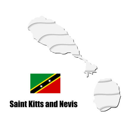
Isometric map of Saint Kitts and Nevis detailed vector illustration. Isolated 3D isometric country concept for infographic
Коллекция по умолчанию
Коллекция по умолчанию
Создать новую
Uganda map on white background. vector illustration.
Коллекция по умолчанию
Коллекция по умолчанию
Создать новую

Character with the flag of Saint Kitts and Nevis. Teaching children geography and countries of the world
Коллекция по умолчанию
Коллекция по умолчанию
Создать новую

Saint Kitts and Nevis National Flag Template Design. Vector Illustration.
Коллекция по умолчанию
Коллекция по умолчанию
Создать новую

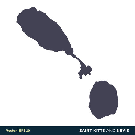
Map of Saint Kitts and Nevis vector
Коллекция по умолчанию
Коллекция по умолчанию
Создать новую

waving flag of Saint Kitts and Nevis on white background. Template for independence day. vector illustration
Коллекция по умолчанию
Коллекция по умолчанию
Создать новую

Voreiio Aigaio Greece Map in grey
Коллекция по умолчанию
Коллекция по умолчанию
Создать новую

An Illustration on a White background of Honduras
Коллекция по умолчанию
Коллекция по умолчанию
Создать новую

Territory of Saint Kitts and Nevis
Коллекция по умолчанию
Коллекция по умолчанию
Создать новую

Dominicana area map in the Azimuthal Equidistant projection. color physical map. Overlay with clean background, borders and graticule
Коллекция по умолчанию
Коллекция по умолчанию
Создать новую

National Flag of Saint Kitts and Nevis. Federation of Saint Christopher and Nevis Country Flag Detailed Banner. EPS Vector Illustration Cut File
Коллекция по умолчанию
Коллекция по умолчанию
Создать новую

Close up grungy, damaged and weathered Tanzania flag on wall peeling off paint to see inside surface.
Коллекция по умолчанию
Коллекция по умолчанию
Создать новую

Bioko Sur, province of Equatorial Guinea. Open Street Map. Locations and names of major cities of the region. Corner auxiliary location maps
Коллекция по умолчанию
Коллекция по умолчанию
Создать новую
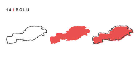
Turkey, Bolu city map. Simple vector illustration isolated on a white background.
Коллекция по умолчанию
Коллекция по умолчанию
Создать новую

Zamboanga del Norte, province of Philippines. Colored elevation map with lakes and rivers
Коллекция по умолчанию
Коллекция по умолчанию
Создать новую

Saint Kitts and Nevis flag is shown on an open matchbox, from which several matches fall and lies on a large flag.
Коллекция по умолчанию
Коллекция по умолчанию
Создать новую

East Timor area map in the Azimuthal Equidistant projection. color physical map. Clean shape without borders
Коллекция по умолчанию
Коллекция по умолчанию
Создать новую

Map of Timor-Leste. Mosaic style map with flag of Timor-Leste. Curious vector illustration.
Коллекция по умолчанию
Коллекция по умолчанию
Создать новую

Travel to Saint Kitts and Nevis. Discover and explore new countries. Adventure trip
Коллекция по умолчанию
Коллекция по умолчанию
Создать новую
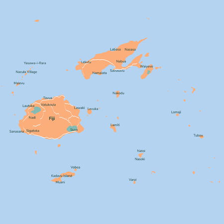
Vector map Fiji. Isolated vector Illustration. EPS 10 Illustration.
Коллекция по умолчанию
Коллекция по умолчанию
Создать новую
Saint Kitts and Nevis - North America Countries Map Icon Vector Logo Template Illustration Design. Vector EPS 10.
Коллекция по умолчанию
Коллекция по умолчанию
Создать новую

Jamaica area map in the Azimuthal Equidistant projection. color physical map. Overlay with clean background, borders and graticule
Коллекция по умолчанию
Коллекция по умолчанию
Создать новую

Vector map Comoros. Isolated vector Illustration. Black on White background. EPS 10 Illustration.
Коллекция по умолчанию
Коллекция по умолчанию
Создать новую

Manus, province of Papua New Guinea. Open Street Map
Коллекция по умолчанию
Коллекция по умолчанию
Создать новую

Caribbean on gray political globe with embedded flag. 3D illustration.
Коллекция по умолчанию
Коллекция по умолчанию
Создать новую

Skane, county of Sweden. Elevation map colored in wiki style with lakes and rivers
Коллекция по умолчанию
Коллекция по умолчанию
Создать новую

Closeup old retro red green color vintage sea st land day war unity silk cloth stripe shape view text space.
Коллекция по умолчанию
Коллекция по умолчанию
Создать новую

very big size illustration samoa country map with flag
Коллекция по умолчанию
Коллекция по умолчанию
Создать новую
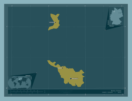
Bremen, state of Germany. Solid color shape. Locations and names of major cities of the region. Corner auxiliary location maps
Коллекция по умолчанию
Коллекция по умолчанию
Создать новую

Curved ribbon with fllag of Saint Kitts and Nevis on white background with copyspace
Коллекция по умолчанию
Коллекция по умолчанию
Создать новую
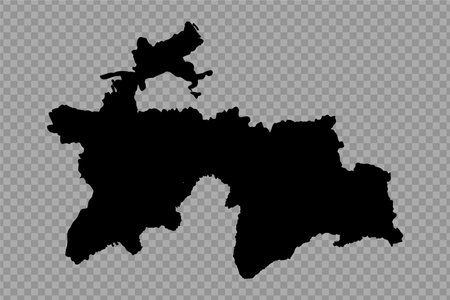
Transparent Background Tajikistan Simple map, can be used for business designs, presentation designs or any suitable designs.
Коллекция по умолчанию
Коллекция по умолчанию
Создать новую

Malaysia map with administrative divisions. Vector illustration.
Коллекция по умолчанию
Коллекция по умолчанию
Создать новую

Tanzania Metallic flag, Textured flag, grunge flag
Коллекция по умолчанию
Коллекция по умолчанию
Создать новую
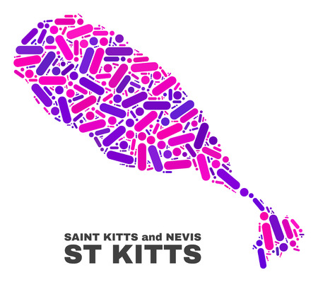
Mosaic St Kitts Island map isolated on a white background. Vector geographic abstraction in pink and violet colors. Mosaic of St Kitts Island map combined of random round points and lines.
Коллекция по умолчанию
Коллекция по умолчанию
Создать новую

vector map and flag of congo
Коллекция по умолчанию
Коллекция по умолчанию
Создать новую

High resolution topographic map of Hawaii
Коллекция по умолчанию
Коллекция по умолчанию
Создать новую

Map illustration of Dominica with the flag. Cartographic illustration of Dominica and neighboring countries. Vector map and flag.
Коллекция по умолчанию
Коллекция по умолчанию
Создать новую
Abstract country map with states divions on a white background
Коллекция по умолчанию
Коллекция по умолчанию
Создать новую

Saint Kitts and Nevis paper flag. Patriotic background. National flag of Saint Kitts and Nevis
Коллекция по умолчанию
Коллекция по умолчанию
Создать новую

Shape of Islas Baleares, autonomous community of Spain, with its capital isolated on white background. Bilevel elevation map. 3D rendering
Коллекция по умолчанию
Коллекция по умолчанию
Создать новую

Morobe, province of Papua New Guinea. Low resolution satellite maps
Коллекция по умолчанию
Коллекция по умолчанию
Создать новую

An Illustration on an Orange background of Estonia
Коллекция по умолчанию
Коллекция по умолчанию
Создать новую

September 19, Independence Day of Saint Kitts and Nevis. vector illustration. Suitable for greeting card, poster and banner.
Коллекция по умолчанию
Коллекция по умолчанию
Создать новую

Map of Guyana with embedded national flag on globe, top-down view. 3D illustration
Коллекция по умолчанию
Коллекция по умолчанию
Создать новую

Lautem, municipality of East Timor. High resolution satellite map. Locations and names of major cities of the region. Corner auxiliary location maps
Коллекция по умолчанию
Коллекция по умолчанию
Создать новую

vector map of the portuguese archipelago Azores in the Atlantic ocean with flag, Portugal
Коллекция по умолчанию
Коллекция по умолчанию
Создать новую

Vieques, municipality of Puerto Rico. Low resolution satellite maps
Коллекция по умолчанию
Коллекция по умолчанию
Создать новую

Tuen Mun district map, administrative division of Hong Kong. Vector illustration.
Коллекция по умолчанию
Коллекция по умолчанию
Создать новую
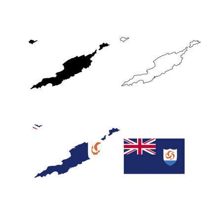
Map of Anguilla
Коллекция по умолчанию
Коллекция по умолчанию
Создать новую

Colon, province of Panama. Elevation map colored in wiki style with lakes and rivers
Коллекция по умолчанию
Коллекция по умолчанию
Создать новую

Vector isolated illustration of simplified administrative map of Saint Kitts and Nevis. Borders and names of the parishes (regions). Colorful blue khaki silhouettes.
Коллекция по умолчанию
Коллекция по умолчанию
Создать новую

Map illustration of Jamaica with the flag. Cartographic illustration of Jamaica and neighboring countries. Vector map and flag.
Коллекция по умолчанию
Коллекция по умолчанию
Создать новую
Highly detailed Comoros map with borders isolated on background. Simple flat icon illustration for web
Коллекция по умолчанию
Коллекция по умолчанию
Создать новую

Ucayali, region of Peru. solid color shape. Locations and names of major cities of the region. Corner auxiliary location maps
Коллекция по умолчанию
Коллекция по умолчанию
Создать новую

Shape of Isiolo, county of Kenya, with its capital isolated on a solid color background. Satellite imagery. 3D rendering
Коллекция по умолчанию
Коллекция по умолчанию
Создать новую
Absheron, region of Azerbaijan. Elevation map colored in wiki style with lakes and rivers
Коллекция по умолчанию
Коллекция по умолчанию
Создать новую

Honduras vector country map
Коллекция по умолчанию
Коллекция по умолчанию
Создать новую
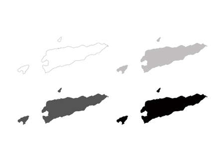
vector illustration of East Timor map
Коллекция по умолчанию
Коллекция по умолчанию
Создать новую

Shefa province map, administrative division of Vanuatu. Vector illustration.
Коллекция по умолчанию
Коллекция по умолчанию
Создать новую
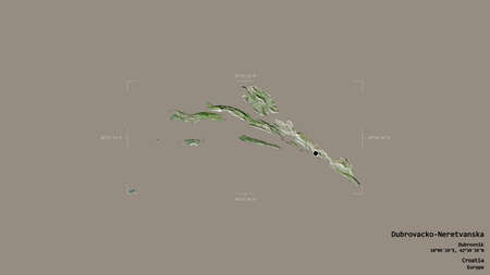
Area of Dubrovacko-Neretvanska, county of Croatia, isolated on a solid background in a georeferenced bounding box. Labels. Satellite imagery. 3D rendering
Коллекция по умолчанию
Коллекция по умолчанию
Создать новую
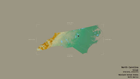
Area of North Carolina, state of Mainland United States, isolated on a solid background in a georeferenced bounding box. Labels. Topographic relief map. 3D rendering
Коллекция по умолчанию
Коллекция по умолчанию
Создать новую

Dominicana area map in the Azimuthal Equidistant projection. color physical map. Clean shape with borders and graticule
Коллекция по умолчанию
Коллекция по умолчанию
Создать новую
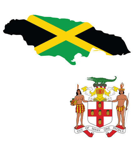
Flag and coat of arms of Jamaica overlaid on outline map isolated on white background
Коллекция по умолчанию
Коллекция по умолчанию
Создать новую
Haiti on 3D model of globe with real land surface, visible country borders and water in place of ocean. 3D illustration.
Коллекция по умолчанию
Коллекция по умолчанию
Создать новую

Zamboanga del Norte, province of Philippines. Elevation map colored in wiki style with lakes and rivers. Locations and names of major cities of the region. Corner auxiliary location maps
Коллекция по умолчанию
Коллекция по умолчанию
Создать новую

Saint Kitts and Nevis islands official flag
Коллекция по умолчанию
Коллекция по умолчанию
Создать новую

A Country Shape Illustration of Monaco
Коллекция по умолчанию
Коллекция по умолчанию
Создать новую

Vector set of the coat of arms and national flag of Saint Kitts and Nevis
Коллекция по умолчанию
Коллекция по умолчанию
Создать новую
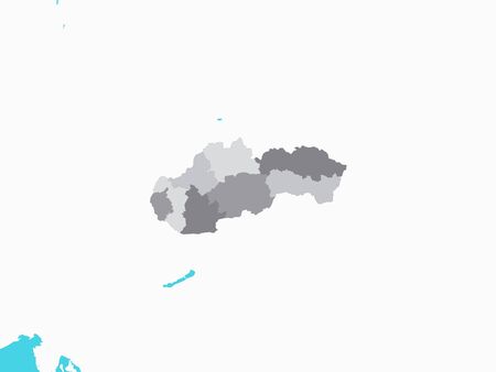
Gray Map of Regions of Slovakia with Surrounding Terrain
Коллекция по умолчанию
Коллекция по умолчанию
Создать новую

Detailed vector Singapore country border map isolated on background. East islands country template for pattern, report, infographic, banner. Asia nation business silhouette sign concept
Коллекция по умолчанию
Коллекция по умолчанию
Создать новую

Illustration of the Saint Kitts and Nevis flags on map of country; isolated on white background.
Коллекция по умолчанию
Коллекция по умолчанию
Создать новую

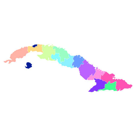
Camaguey, province of Cuba. Sentinel-2 satellite imagery. Shape isolated on solid background with informative overlays. Contains modified Copernicus Sentinel data
Коллекция по умолчанию
Коллекция по умолчанию
Создать новую

Suhaj, governorate of Egypt. Solid color shape. Locations and names of major cities of the region. Corner auxiliary location maps
Коллекция по умолчанию
Коллекция по умолчанию
Создать новую
Republic of Cyprus map with administrative divisions. Vector illustration.
Коллекция по умолчанию
Коллекция по умолчанию
Создать новую

Flag of Federation of Saint Kitts and Nevis in official colors and proportions, vector image
Коллекция по умолчанию
Коллекция по умолчанию
Создать новую

raster illustration flag of Saint Kitts and Nevis icon. Rectangle national flag of Saint Kitts and Nevis. Saint Kitts and Nevis flag button
Коллекция по умолчанию
Коллекция по умолчанию
Создать новую

Italy map silhouette with hanging sign plate. Closed for quarantine due to coronavirus. Italy is isolated from the whole world. Stay home during Covid-19. Stop the madness during Quarantine.
Коллекция по умолчанию
Коллекция по умолчанию
Создать новую

Northland, regional council of New Zealand. Elevation map colored in wiki style with lakes and rivers
Коллекция по умолчанию
Коллекция по умолчанию
Создать новую

Orkney Islands, region of Scotland - Great Britain. Open Street Map
Коллекция по умолчанию
Коллекция по умолчанию
Создать новую

LGBT flag map of Saint Kitts and Nevis. Vector rainbow map of Saint Kitts and Nevis in colors of LGBT (lesbian, gay, bisexual, and transgender) pride flag.
Коллекция по умолчанию
Коллекция по умолчанию
Создать новую

Two versions of a folded map of Central African Republic with the flag of the country of Central African Republic and with the red color highlighted. Set of isometric vector maps.
Коллекция по умолчанию
Коллекция по умолчанию
Создать новую
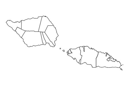
Outline Sketch Map of Samoa With States and Cities, can be used for business designs, presentation designs or any suitable designs.
Коллекция по умолчанию
Коллекция по умолчанию
Создать новую

Map illustration of Nauru with the flag. Cartographic illustration of Nauru and neighboring countries. Vector map and flag.
Коллекция по умолчанию
Коллекция по умолчанию
Создать новую

Absheron, region of Azerbaijan. Open Street Map
Коллекция по умолчанию
Коллекция по умолчанию
Создать новую
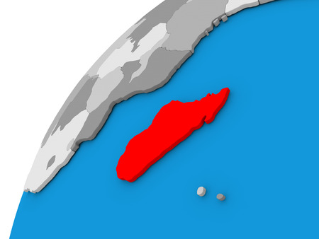
Madagascar highlighted in red on globe with visible country borders. 3D illustration
Коллекция по умолчанию
Коллекция по умолчанию
Создать новую

Chiba, prefecture of Japan. Elevation map colored in wiki style with lakes and rivers
Коллекция по умолчанию
Коллекция по умолчанию
Создать новую
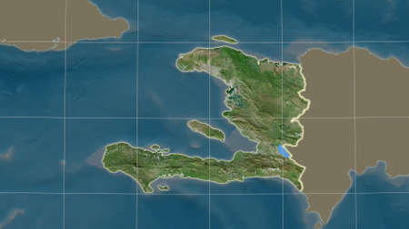
Haiti area map in the Azimuthal Equidistant projection. satellite imagery. Overlay with clean background, borders and graticule
Коллекция по умолчанию
Коллекция по умолчанию
Создать новую
Closeup old retro red green color vintage sea st land day war unity silk cloth stripe shape view text space. Print web art elect trade unit sport ensign logo label frame badge insignia element badge set
Коллекция по умолчанию
Коллекция по умолчанию
Создать новую

Crying woman, pain and grief concept, flag of Saint Kitts and Nevis
Коллекция по умолчанию
Коллекция по умолчанию
Создать новую

Flag of Kenya on globe. Official flag colours, accurate country borders. 3D illustration
Коллекция по умолчанию
Коллекция по умолчанию
Создать новую
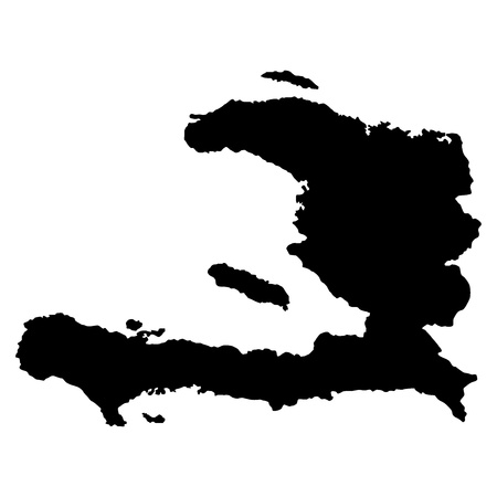
Vector illustration of maps of Haiti
Коллекция по умолчанию
Коллекция по умолчанию
Создать новую

Guinea during sunset highlighted in red on planet Earth with visible country borders. 3D illustration.
Коллекция по умолчанию
Коллекция по умолчанию
Создать новую
Vector Map of Gansu Province. Composition of green grape leaves, wine bottles. Map of Gansu Province mosaic designed with bottles, grapes, green leaves.
Коллекция по умолчанию
Коллекция по умолчанию
Создать новую

Hokkaido, circuit of Japan. Elevation map colored in wiki style with lakes and rivers. Locations and names of major cities of the region. Corner auxiliary location maps
Коллекция по умолчанию
Коллекция по умолчанию
Создать новую

Flag of Tanzania
Коллекция по умолчанию
Коллекция по умолчанию
Создать новую

Yogyakarta, special region of Indonesia. Colored elevation map with lakes and rivers
Коллекция по умолчанию
Коллекция по умолчанию
Создать новую

Saint Kitts and Nevis country flag on wavy silk textile fabric background.
Коллекция по умолчанию
Коллекция по умолчанию
Создать новую

Map of Haiti isolated on transparent background
Коллекция по умолчанию
Коллекция по умолчанию
Создать новую

Коллекция по умолчанию
Коллекция по умолчанию
Создать новую

Vector Illustration of the Flag Map of Japanese Prefecture of Kagawa
Коллекция по умолчанию
Коллекция по умолчанию
Создать новую
Legion-Media
Создайте свои проекты на основе качественных стоковых фотографий и видео.


Copyright © Legion-Media.